


VFRnav flight navigation
VFRnav flight navigation açıklaması
VFRnav is a flight navigation application for VFR pilots.
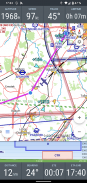
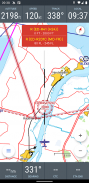
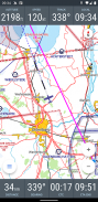
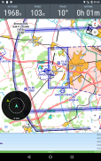
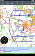
The moving map in the well known IC*O-style supports the pilot with the navigation and thus leaves time for the bright side of flighing.
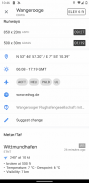
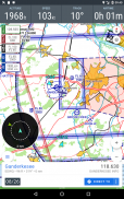
The integrated database includes over 4,500 airfields and waypoints from many european countries with information about airport names, frequency and runway information. A "double tab" on any point on the map shows this additional information.
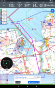
By the support of the OpenAir file format, any airspaces (including gliding sectors) can be shown on the map.
Especially helpful: After downloading the desired maps (completely free) as well as the airspace files, VFRnav works completely offline and does not require an existing data connection at any time. Not even a SIM must be available in your smartphone. (Advise: For optimal battery life it is recommended to switch on the flight mode during your trip)
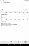
With the track recording feature you can track any flights. Tracks can be exported as KML files and/or sent by e-mail . Flown routes can be shown on Google Earth. The flight time recording also automatically records time and place of takeoff and landing and calculates the time of flight.
The development of VFRnav is made in close contact with the users. We set a high value on the intuitive use and usability as well as an Android typical app-design. In the current second version many ideas and suggestions have been implemented which have reached us in the past few months by e-mail. Thank you at this point for the extensive feedback.
The basic functions of VFRnav can be tested without any time limitation. If you like VFRnav, you can purchase a license for currently 49,95 Euros. This will give you free updates for one year. After the 12 months a lower priced update license can be purchased. VFRnav itself can be used unlimited.
By the way: The license is personal but not linked to any specific device. If you use multiple Android devices with the same Google account, your license is valid on all your devices.
Requirements: For the real time air navigation a device with GPS is required. Furthermore your smartphone or tablet needs at least 200 MB of free space. VFRnav has been tested on Android 2.2 up to 6.0 (Marshmallow) . A minimum display resolution of 480x800 pixels is recommended.
If you have any questions do not hesitate to contact us by e-mail.
Disclaimer: Please note that VFRnav is not an officially approved aid for the flight preparation and air navigation. A guarantee for the correctness and completeness of data cannot be given. We are not responsible for any use of this application. Please check the data displayed always with official maps of aviation.
VFRnav est une application de navigation aérienne pour les pilotes VFR.
</div> <div jsname="WJz9Hc" style="display:none">VFRnav VFR pilotlar için uçuş navigasyon uygulamasıdır.
Iyi bilinen IC hareketli harita * O tarzı navigasyon ile pilota destekler ve böylece flighing aydınlık tarafı için zaman bırakır.
Entegre veritabanı havaalanı isimleri, sıklık ve pist bilgileri hakkında bilgi birçok Avrupa ülkesinden 4.500 üzerinde havaalanlarını ve yol işaretleri içerir. Harita üzerinde herhangi bir noktaya bir "çift sekmesi" bu ek bilgileri gösterir.
OpenAir dosya biçimi desteği ile, (kayma sektörleri dahil) Havasahaları harita üzerinde gösterilebilir.
Özellikle yararlı: İstenen haritalar (tamamen ücretsiz) yanı sıra hava sahasını dosyaları indirdikten sonra VFRnav tamamen çevrimdışı çalışıyor ve herhangi bir zamanda varolan bir veri bağlantısı gerektirmez. Hatta bir SIM akıllı telefonunuza mevcut olmalıdır. (Tavsiye: Bu seyahatiniz sırasında uçuş moduna geçiş yapmak için tavsiye edilir Optimum pil ömrü için)
Track kayıt ile herhangi bir uçuş izleyebilirsiniz sahiptir. Traklar KML dosyaları olarak dışa ve / veya e-posta ile gönderilebilir. Uçakla yolları Google Earth'te gösterilebilir. Uçuş süresi, kayıt otomatik olarak kalkış ve iniş zamanı ve yeri kaydeder ve uçuş süresini hesaplar.
VFRnav gelişimi kullanıcıları ile yakın temas içinde yapılır. Biz yüksek sezgisel kullanım değerini ve kullanılabilirlik yanı sıra Android tipik app-tasarım ayarlayın. Mevcut ikinci versiyonda birçok fikir ve öneri e-posta ile son birkaç ay içinde bize ulaşmış olan uygulanmıştır. Kapsamlı geribildirim için bu noktada teşekkür ederiz.
VFRnav temel işlevleri herhangi bir zaman sınırlaması olmaksızın test edilebilir. Eğer VFRnav isterseniz, şu anda 49,95 Euro için bir lisans satın alabilirsiniz. Bu bir yıl boyunca size ücretsiz güncellemeler verecektir. 12 ay sonra daha düşük fiyatlı güncelleme lisansı satın alınabilir. VFRnav kendisini sınırsız kullanılabilir.
Bu arada: Lisans kişisel ama herhangi bir özel cihaza bağlı değil. Aynı Google hesabı ile birden çok Android cihaz kullanıyorsanız, lisans tüm cihazlarınızda geçerlidir.
Gereksinimler: Gerçek zamanlı hava navigasyon için GPS ile bir cihaz gereklidir. Ayrıca akıllı telefon ya da tablet boş alan en az 200 MB'lik. VFRnav 6.0 (Zefir) kadar Android 2.2 üzerinde test edilmiştir. 480x800 piksel minimum ekran çözünürlüğü tavsiye edilir.
Eğer herhangi bir soru e-mail yoluyla bizimle irtibata geçmekten çekinmeyin.
Yasal Uyarı: VFRnav uçuş hazırlığı ve hava navigasyon için resmi onaylı bir yardım olmadığını unutmayınız. Verilerin doğruluğu ve bütünlüğü için bir garanti verilemez. Biz bu uygulamanın herhangi bir şekilde kullanımından sorumlu değildir. Havacılık resmi haritalar ile her zaman görüntülenir verileri kontrol edin.
VFRnav est une uygulama de gezinme aérienne les Pilotes VFR dökün.</div> <div class="show-more-end">
VFRnav flight navigation - Sürüm 4.8.0
(15-03-2025)VFRnav flight navigation - APK Bilgisi
APK sürümü: 4.8.0Paket: com.flugbetrieb.VFRnav

 4.75
4.75


Aynı kategorideki uygulamalar

Hoşuna gidebilecekler...


